
Did the Forest Service learn from the Biscuit fire (2002)?
From the Biscuit Burn to the Chetco Bar fire
...with the passage of time it is now possible to look back more objectively at Biscuit fire and the political firestorm that followed in its wake.
On July 13, 2002, a series of electrical storms passed over southwestern Oregon's Siskiyou Mountains. That afternoon's barrage of lightning strikes ignited five separate fires inside the vast Kalmiopsis Wilderness. Burning for well over four months in remote and rugged terrain, by early August the fires had grown together into a single blaze. The U.S. Forest Service dubbed it the Biscuit Fire.
Fast forward to 15 years minus one day, July 12, 2017, lighting strikes deep in the heart of the Kalmiopsis Wilderness near the Chetco River igniting the Chetco Bar Fire. Three days later, on the 15th of July, the Chetco Bar fire was located within in the fire scar of the 2002, Biscuit Fire and was limited to a mere 45 acres.
This area is known locally as having a “Chetco Effect” a weather pattern created by gusty northeast winds that bring warm dry airs down through the valleys out to sea. The Chetco Bar Fire burned over a large geographic region where significant variation in topography, vegetation, and climate exists. Activity increased significantly during August 17th and August 21st growing to 97,758 acres. On August 22nd the incident meteorologist warned of the Chetco Effect to return over the fire area. On September 3rd, High temperatures and critically low humidity contributed to the increase in fire behavior. On the eastern flank, a significant smoke column developed to a height of 23,000 feet. Once contained, the Chetco Bar Fire had burned 191, 197 acres and was named Oregon’s largest wildfire of 2017.
Mitch Ward, the Chetco Bar Fire public information officer told the Statements Journal, “It did burn a lot of forest that didn’t get burned by Biscuit, but this time it was more of a mosaic. The fire burned hottest on the ridges as opposed to the lower-drainage areas, where it mostly burned undergrowth.” The Rogue River Siskiyou National Forest updated their Facebook page on August 11th to say, “The fire is naturally burning in a mosaic pattern, leaving behind a mixture of unburned fuel islands, moderately burned areas and some high severity burn areas.”
The forests of the Kalmiopsis Wilderness have historically been fire-dependent—that is, requiring frequent low-intensity fires to clear out undergrowth so that widely scattered trees can thrive. Similarly, to the Chetco Bar fire, the patterns of the Biscuit fire mosaic were further defined by a previous fire that burned the same area 15 years earlier—the Silver Fire of 1987.
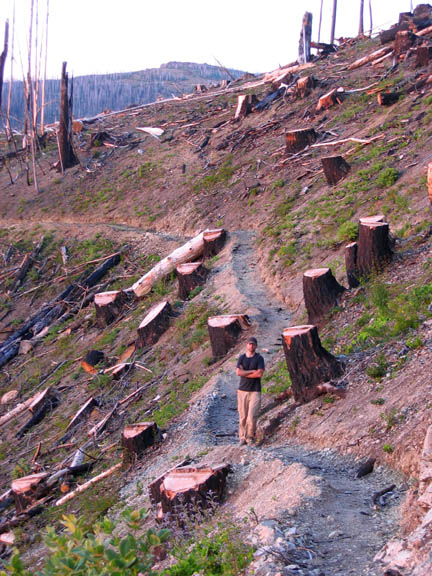
Baby Foot Lake, Biscuit Fire Timber Unit, turned into a stump field
What To Do With a Burned Biscuit
Following wildfire, land managers typically make decisions about post-fire management, such as whether to conduct logging, plant vegetation, or manage erosion; and if any treatments are applied, they need to decide how large an area to treat and how quickly. Complex factors also are evaluated, including fire histories, previously applied management actions, characteristics of soils and hydrology, wildlife living in the forest, societal goals for the forested area, proximity of homes and businesses, proximity and condition of other forests, and anticipated future climates. Often, re-growth of vegetation, which is called regeneration, is a top priority.
In response to the Biscuit fire, the U.S. Forest Service claimed that the ecosystem needed aggressive “salvage” logging to regenerate new forests and reduce future fire hazard, and that the local economy needed the timber. The Forest Service adopted a “log across the landscape approach” even though, in general, post-fire revegetation is rapid and profuse in the Klamath-Siskiyou Ecoregion without the help of man. In the Klamath-Siskiyou‘s, a natural seed source is available in most instances even after a severe fire. Burned trees harbor the keys to the future: the nutrients that will feed the forest's re-growth.
For the Biscuit, including roadless areas, late successional reserves and matrix lands, a logging alternative that cut a billion board feet and an alternative that cut 518 million board feet were proposed. Theory being that the final proposal to remove 372 million board feet from the forest would look reasonable in comparison.
Even with the extreme conditions present at the time of the Biscuit burn, the fire did not uniformly blacken the landscape, rather it burned in all severity classes in a mosaic pattern. Those who would say that wilderness protections increased the effects of the fire ignore the high severity mortality that occurred in the dense fiber plantations surrounding the wilderness and the impacts of Forest Service fire fighting techniques that were intended to blacken green forest stands. What tends to be forgotten is that thousands of acres of intense fire behavior were the result of deliberate back-burning and burnout operations by the Forest Service.
The agency’s 2003 Post-Fire Assessment found that the severe fire activity closest to the Illinois Valley communities was the result of intentional backfiring. Similarly, the portion of the fire that consumed several homes and structures around Oak Flat was started as intentional burnout.
The point here is that fire behavior in Biscuit was the result of a number of complex factors that included drought, weather, topography, and Forest Service ignition.
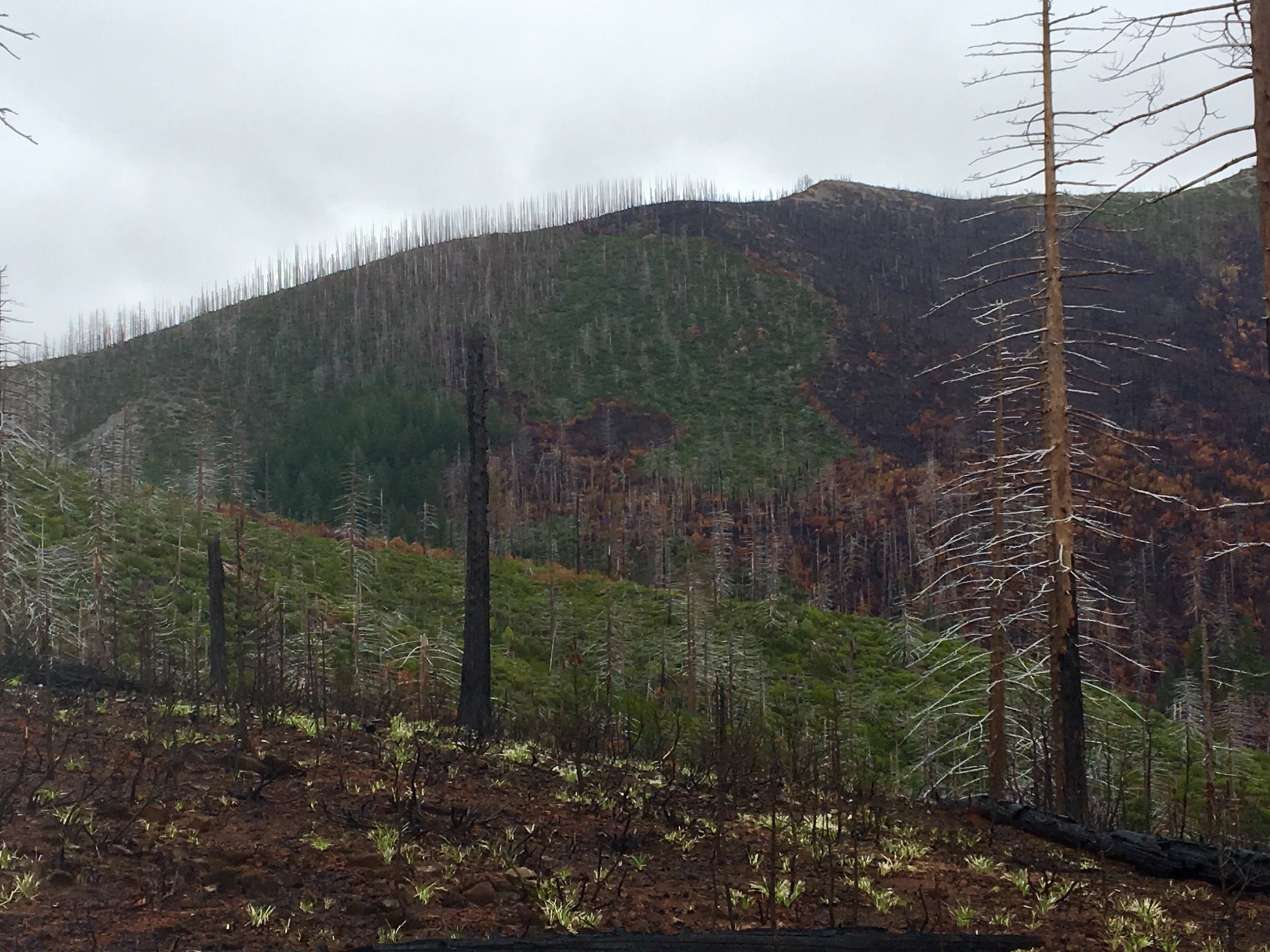
Chetco Bar Fire, Kalmiopsis Wilderness, Mosaic Burn Pattern
Fast Forward 15 Years
The Chetco Bar fire burned in the same complex topographical location experiencing similar complex factors of drought and weather as did Biscuit. Out of the 191,197 acres that eventually burned in the Chetco Bar Fire, 80% burned within the Chetco River watershed. The east side of the fire burned in a large portion of the Kalmiopsis Wilderness, which for the most case overlaps with the area that was burned by Biscuit.
The Kalmiopsis Wilderness is an insight into an area of our public lands which has endured three major wildfires in the last thirty years and in which subsequent biodiversity has flourished. In between the pockets of higher intensity fire one will discover rich, lush, and vibrant life. You can find Port Orford Cedars within their limited native range of Southwest Oregon and northwest California growing amongst the burn. Darlingtonias, or Cobra Lillies, decorate riparian areas in fens of hundred carnivorous plants. Namesake Kalmiopsis wildflowers proliforate.
The Kalmiopsis Wilderness is a place of dreams, described by many who have come to explore this rough and rugged territory. The fires that have swept through the watershed in the last fifteen years have made a beneficial on the wildlife that calls this wilderness home. By eliminating undergrowth, openings have been made to enable new growth and expansion by standing living trees. Standing dead trees burned by wildfire provide necessary habitat for many animals.
Allowing hindsight to play a role in future decisions may enable agencies to make better choices when managing the Chetco Bar fire. When assessing the successfulness of fireline utilization, the lessons from the Biscuit backburns employed by the Forest Service, were not forgotten. When drawing contingency lines, operations primarily identified existing roads and trails, and improved lines used previously in the Biscuit. The increased fire behavior, forecast weather, and steep topography contributed to the challenges for fire resources to safely engage in direct fire suppression. The Forest Service unlike in the Biscuit is not proposing harvest in Late Successional Reserves or Roadless Areas. Their efforts are focused in the Matrix land designation but the question remains, how much?