
The Wild and Scenic Rogue River
From its source in the high Cascade Mountains in southwestern Oregon near Crater Lake National Park, the Rogue, one of the longest rivers in Oregon, tumbles and flows more than 200 miles, entering the Pacific Ocean at Gold Beach. One of the eight rivers established with passage of the Wild and Scenic Rivers Act in 1968, the designated segment of the Rogue extends from the mouth of the Applegate River (about six miles downstream from Grants Pass) to the Lobster Creek Bridge (about eleven miles upstream from its mouth), a total distance of 84 miles. The first 47 miles are administered by the Medford District BLM, and the remaining 37 miles are administered by the Siskiyou National Forest.
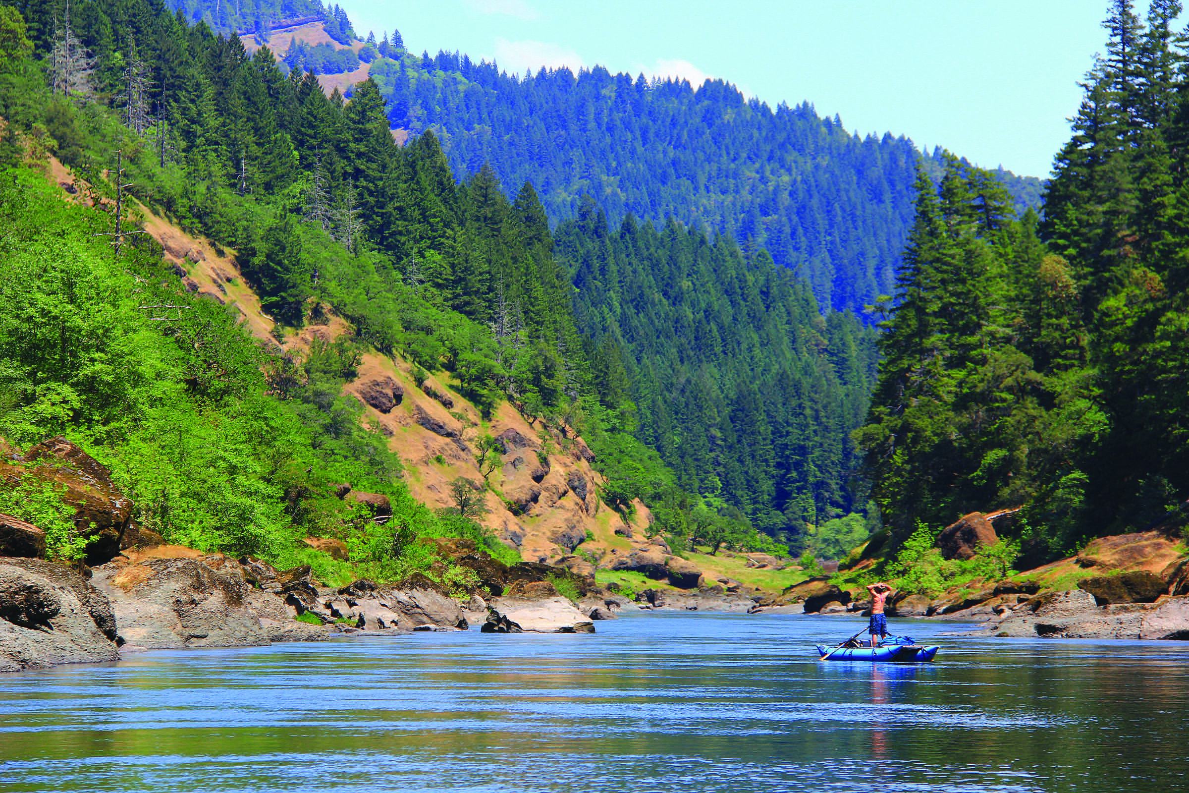
The Rogue River is known nationally for its salmon and steelhead fishing and high-quality whitewater boating opportunities.
The lure of gold in the 1850's attracted a numbers of miners, hunters, stocker raisers and subsistence farmers. Conflicts between white settlers and Native Americans culminated in the 1855-56 Rogue River "Indian War," after which Native Americans relocated to reservations. For settlers, life in the Rogue Canyon was difficult and isolated. While gold mining operations were extensive, overall production was low. The remnants of mining, such as pipe, flumes, trestles and stamp mills can still be found.
Outstandingly Remarkable Values
The Rogue River is home to a variety of species, including chinook salmon, coho salmon, steelhead, cutthroat trout and green sturgeon. The adult fish use the clean river substrate to deposit their eggs. The eggs then remain in the gravel for several months. After hatching, some species such as coho, steelhead and green sturgeon, rear within the river from one to three years, while others such as chinook begin the journey to the ocean and will eventually make their way back to their natal stream to spawn.
It is not uncommon to see black bears, deer, otters, great blue herons and ospreys looking for a meal of salmon.

The Wild and Scenic Lower Rogue has a recreational, wild, and scenic sections along 94 river miles.
Recreational
The Rogue River area sees over a half million visitors each year. Recreation opportunities include driving for pleasure, boating, fishing, guided motorized tour boat trips, guided whitewater fishing and float trips, camping, hiking, swimming, picnicking, wildlife viewing, sun bathing and gold panning.
Scenic
Surrounding the Rogue River, the rugged and complex canyon landscape of the Wild Rogue Wilderness was partly designed to provide watershed protection for the wild section of the Rogue River. The established boundary assured preservation of a rugged and complex canyon landscape. The area is characterized by steep terrain of near vertical cliffs, razor-sharp ridges and cascading mountain creeks. Look for diverse flora and fauna among the near-vertical cliffs, razor-sharp ridges and cascading waters of numerous mountain creeks of the Rogue River watershed.
Managing Agency:
Bureau of Land Management, Medford District
U.S. Forest Service, Rogue River-Siskiyou National Forest
Designated Reach:
October 2, 1968. The segment of the river extending from the mouth of the Applegate River downstream to the Lobster Creek Bridge.
Classification/Mileage:
Wild — 33.6 miles; Scenic — 7.5 miles; Recreational — 43.4 miles; Total — 84.5 miles.
The Wild and Scenic Upper Rogue
From the Crater Lake National Park boundary downstream to Prospect, this section of the Rogue is paralleled by a major highway and tourist route from the park. Its diverse landscape includes pumice flats, deep gorges and chutes and unique ecological systems.
The Upper Rogue is fed by snowmelt and springs originating on the peaks of the Cascade Range, including the slopes of Mt. Mazama—the volcanic caldera that contains Crater Lake. Along the uppermost portion of the Upper Rogue, the river is narrow and shallow but very swift. Numerous moss-draped snags of lodgepole pines and other trees that have fallen across the river slow its pace only a little. The river has, for a two-mile stretch, carved more than 200' down into the Mazama pumice (which was deposited about 8,000 years ago during the explosion that created Crater Lake). This sheer, white-walled canyon, with the whitewater river glinting in the sunlight far below, is a favorite sight for travelers along Highway 230.
Downstream, the Upper Rogue passes through the narrow, turbulent Rogue Gorge of black lava and soon plunges entirely underground (into a lava tube) for about 250 feet at Natural Bridge. Interpretive trails at both of these places provide good views of the river, with signs that explain the natural history. Fed by tributaries, such as Union Creek and Flat Creek, the river subsequently flows through rugged Takelma Gorge, well out of sight of any road. The Upper Rogue features several waterfalls, although the more spectacular falls are located on tributaries National Creek and Muir Creek.
The entire length of the Upper Rogue Wild and Scenic River is closely followed by the Upper Rogue River Trail, designated a National Recreation Trail. Because of the various road crossings, much of this hiker-only trail (open to equestrians for short sections near Hamaker Campground) is easily traveled for short segments at a time.
In addition to its clear, clean water and scenic beauty, the Upper Rogue is notable for its history. Parallel to Highway 62 between Farewell Bend and Natural Bridge, it passes through part of the Union Creek Historic District, listed on the National Register of Historic Places for the rustic 1920s-30s buildings at Union Creek Resort and the nearby former ranger station. At Union Creek Wayside, a traveler's comfort station along Highway 62, an interpretive kiosk tells the history of Union Creek.
The Upper Rogue is considered extremely hazardous for whitewater boating due to its gorges, chutes and many obstructions, ranging from "sweeper" logs across the river to the underground section at Natural Bridge. For the entire wild section of the Upper Rogue and some portions of the scenic sections, we recommend no boating due to ever-changing instream hazards. Certain portions of the main scenic section of the Upper Rogue can be floated, with hard-shell kayaks being the most appropriate and preferred craft on this challenging section with always changing instream hazards. This is a river for experienced-to-expert boaters.

Managing Agency:
U.S. Forest Service, Rogue River National Forest
Designated Reach:
October 28, 1988. From the Crater Lake National Park boundary downstream to the Rogue River National Forest boundary at Prospect.
Classification/Mileage:
October 2, 1968: Wild — 33.6 miles; Scenic — 7.5 miles; Recreational — 43.4 miles; Total — 84.5 miles.
March 12, 2019: Wild — 91.4 miles; Scenic — 25.7 miles; Recreational — 1.9 miles; Total — 119.0 miles.
Aggregate Totals: Wild — 125.0 miles; Scenic — 33.2 miles; Recreational — 45.3 miles; Total — 203.5 miles.
Thanks to rivers.gov for this information.